As the 2015 Greenland expedition season gets underway, I want to comment on the insurance overlap between research and sport expeditions on the ice sheet.
Greenland can be a very windy place. The world’s fourth fastest observed wind speed, 333 km/h, was clocked at Thule, Northwest Greenland, in a March 1972 storm1. The “piteraq” (or “ambush”) wind is an especially strong type of wind, unique to Greenland, which occurs when katabatic winds align with the regional geostrophic wind field. During piteraq events, relatively cold and dense air not only flows down from the top of the ice sheet under gravity, but is also sucked down by low atmospheric pressure at the coast2. Piteraqs are strongest around the ice sheet periphery, especially in Southeast Greenland, adjacent to the Icelandic Low.
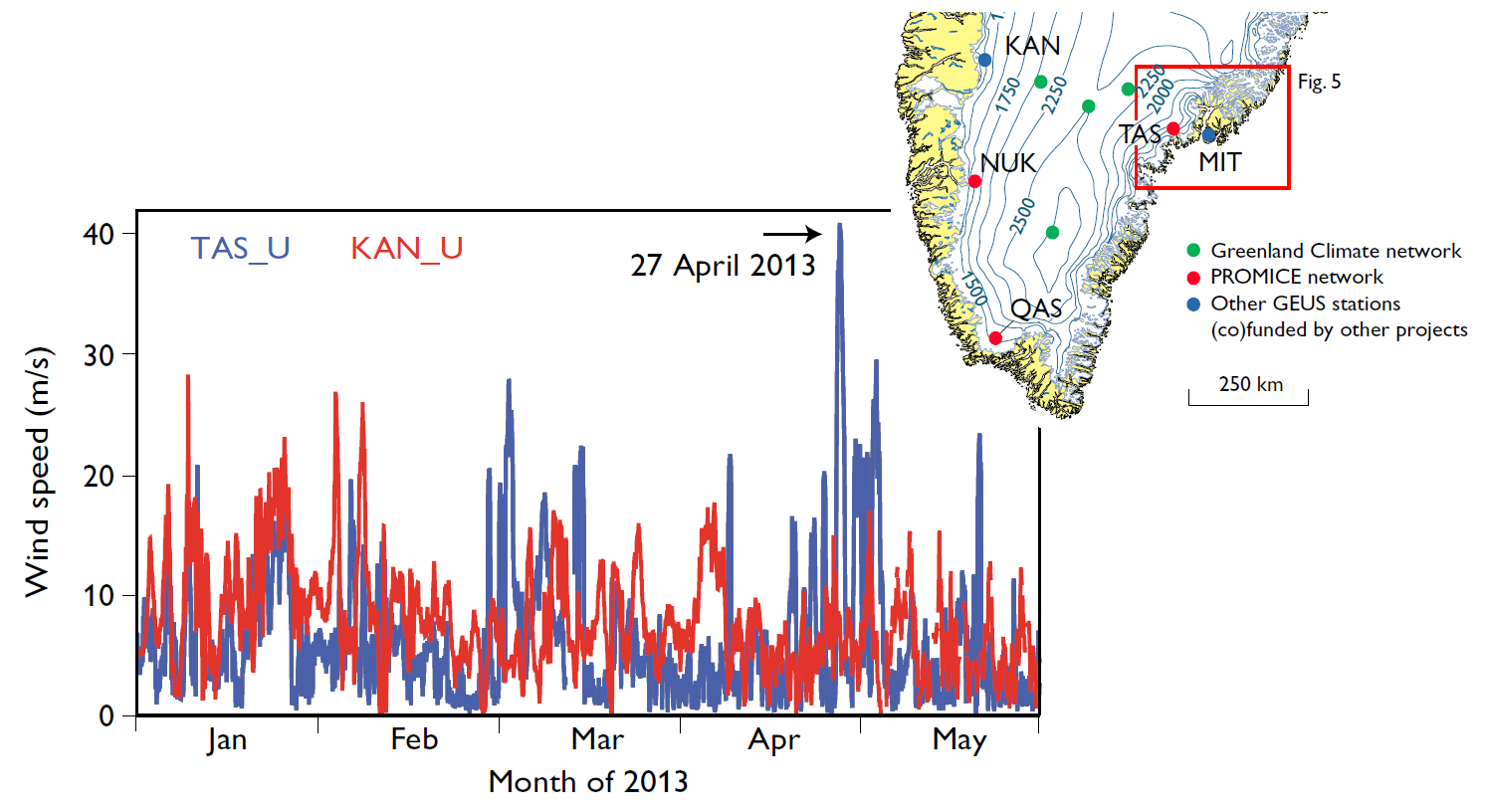
In April 2013, a few colleagues and I were doing fieldwork on the ice sheet at KAN_U in Southwest Greenland, when a piteraq struck Southeast Greenland. Our TAS_U weather station there recorded sustained winds of just over 150 km/hr during the piteraq3. Since 2007, TAS_U has recorded a number of piteraqs, some have even been strong enough to knock over or damage the station. The April 2013 event, which left the TAS_U station standing, would probably not have been noteworthy if it had not claimed the life of Philip Goodeve-Docker, who was just two days into a three-man sport expedition to cross the ice sheet from Isortoq to Kangerlussuaq4.

Mean hourly wind speeds at KAN_U and TAS_U weather stations during the April 2013 piteraq event. Inset: Locations of KAN and TAS transects, as well as other transects, in South Greenland. (source: van As et al., 2014)
The number of annually permitted Greenland sport expeditions is perhaps surprisingly high. An information request to Greenland Government by my colleague, Dirk van As, found that, during the 2010 to 2012 seasons, approximately 78 teams annually undertook sport expeditions in Greenland (including coastal kayaking), of which approximately 24 teams per year were dedicated ice sheet crossings5. Assuming a sport expedition team size of four people, that is approximately 100 individuals per year crossing the ice sheet, mostly along the 67th parallel (the “Isortoq-Kangerlussuaq highway”). All of these sport individuals are obliged to purchase search and rescue (SAR) insurance. While some nationally-funded research expeditions (basically just Danish and American) are permitted to “self-insure”, all other research expeditions have to buy into the same SAR insurance. Occasionally, and strictly speaking, even just specific members of a research expedition, such as persons not employed within the sponsoring nation, may be obliged to purchase their own SAR.

Map of permitted and non-permitted expedition areas in Greenland, as well as the approximate location of the Isortoq-Kangerlussuaq sport route. (source: Greenland Government)
In 2011, I received a SAR quote of 6200 DKK (900 USD) to cover a non-Danish member of a Danish expedition for just eight days. I shudder to think what some colleagues must pay to insure a six person research expedition for a month. At the time, the round-trip helicopter flight to our ice sheet site cost only about ten times our quote premium, meaning that in a zero profit world the underwriters would be recusing approximately 10 % of policyholders. Turns out, that is not far off the truth for sport expeditions. Of the 234 sport expeditions initiated in Greenland between 2010 and 2012, sixteen ended in emergency evacuation5. That is 7 % of all Greenland sport expeditions. The ice sheet teams were evidently better prepared with a lower, but still non-trivial, evacuation rate of 3 %.
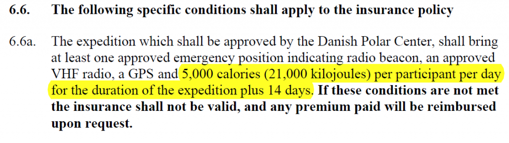
As Greenland SAR insurance treats research and sport expeditions as functionally equivalent, both are technically required to bring more daily calories than even an Olympic swimmer might consume. The above 6.6a clause obliges a 21 day expedition to bring the equivalent of 30 kg of peanut butter per person. (source: Insurance for journeys and expeditions in Greenland policy drawn up in cooperation with the Danish Polar Center conditions no. 101B)
For insurance purposes, both sport and research expeditions are effectively regarded as having the same safety margin. In fact, research expeditions, often delivered by aircraft with >1000 kg of cargo per person, have an inherently higher safety margin than skiers pulling a <200 kg sled. I would love to have the comparable evacuation statistic for research expeditions. We have such an information request pending with Greenland Government, but I will go out on a limb and guess that the research expedition evacuation rate is not nil, but an order of magnitude lower than the sport expedition evacuation. This asymmetry in evacuation risk means that when predominately publicly-funded research expeditions buy SAR insurance, they are effectively subsidizing the SAR costs of predominately privately-funded sport expeditions. To make an analogy, auto insurance rates usually vary between motorcycles and mini-vans. In lieu of different insurance premiums for research and sport expeditions, perhaps the safety of sport expeditions could at least be further optimized by drawing on ice sheet research. (Not forgetting that reducing SAR calls is not just about cost, but also about the preservation of life!)
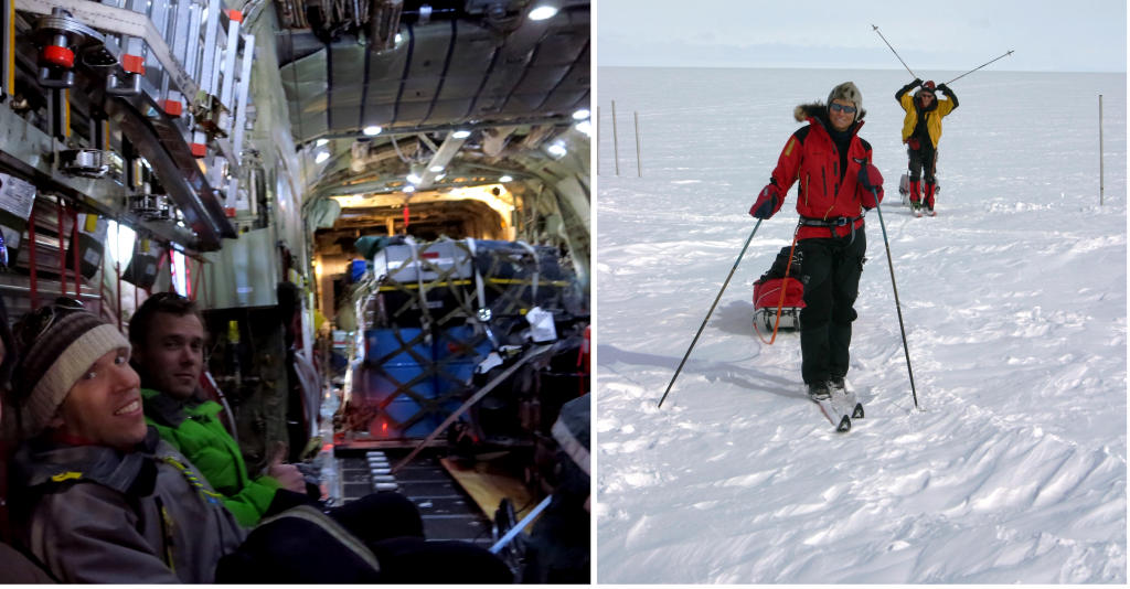
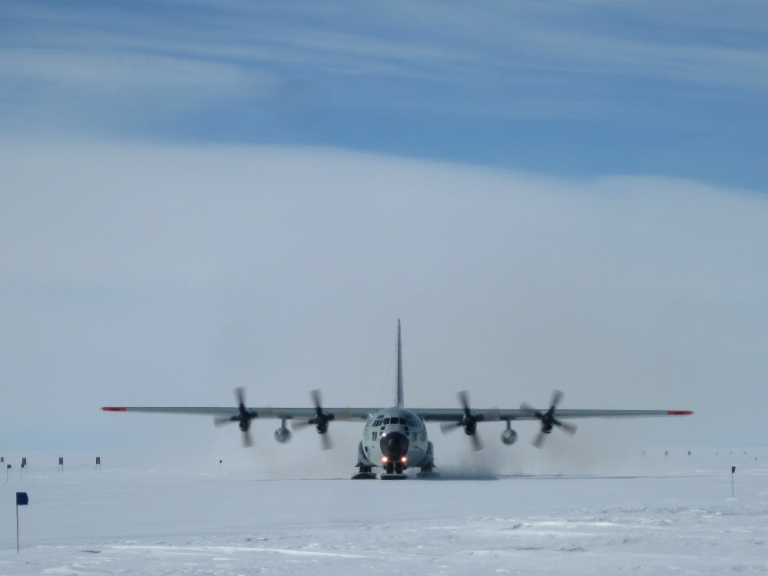
Vastly differing resource levels: Our 2013 research expedition being delivered by LC-130 with two of three pallets (left: Charalampos (Babis) Charalampidis) and a 2008 sport expedition arriving at our West Greenland campsite (right).
This brings us back to piteraqs, which should probably rank at the top of sport expedition hazards, above the more often cited trio of “cold, crevasses and polar bears”. For example, if research suggests that the ice sheet flank is windier in the Southeast than the Southwest, east to west crossings (Isortoq to Kangerlussuaq) would appear to provide sport teams more ample opportunity to wait for an appropriate weather window before setting upon the relatively piteraq prone Southeast flank. Right now, however, the majority of crossings (61 %) are in the opposite direction (west to east), with sport teams arriving in “piteraq alley” with no possibility for retreat5. Danish Meteorological Institute forecasts already include piteraq warnings for Greenland coastal towns. But while research has made piteraqs eminently predictable from 48 hours away, the Goodeve-Docker expedition was jeopardized within 48 hours of departing Isortoq. Evidently, more applied publications and outreach, to better communicate such research insight directly to teams, is needed.
So, those are some thoughts on how sport and research expeditions are linked by common SAR insurance, perhaps arguably to the detriment of research expeditions, and how the piteraq hazard might be mitigated for sport expeditions. Unfortunately, regional climate model simulations suggest that wind speeds around the ice sheet periphery will increase under climate change6, meaning that there will likely be more piteraqs in everyone’s future.
I should probably make explicitly clear that these are my own thoughts, and not those of my employing institution.
1Stansfield, J. 1972. The severe Arctic storm of 8–9 March 1972 at Thule
Air Force Base, Greenland. Weatherwise. 25: 228–233.
2Oltmanns, M., et al. 2014. Strong Downslope Wind Events in Ammassalik, Southeast Greenland. Journal of Climate. 27: 977–993.
3van As, D., et al. 2014. Katabatic winds and piteraq storms: observations from the Greenland ice sheet. Geological Survey of Denmark and Greenland Bulletin. 31: 83-86.
4Edmonds, R. 1 May 2014. Explorer Philip Goodeve-Docker freezes to death on second day of trek across Greenland. London Evening Standard.
5Greenland Government. 2013. Statistik fra Administration af rejseaktivitet I Grønland. 6 pages.
6Gorter, W. et al. 2013. Present and future near-surface wind climate of Greenland from high resolution regional climate modeling. Climate Dynamics. 42: 1595-1611.