Posted by William Colgan
on September 10, 2018
Applied Glaciology,
New Research /
1 Comment
We are starting a new two-year project to design, build and deploy a new type of ice-drill to measure temperatures at the ice-bed interface of the Greenland Ice Sheet. Why? Because we are unsure whether the bed is frozen or thawed beneath about one third of the ice sheet. As the rate at which ice flows is dependent on ice temperature – and basal ice temperature in particular – this translates into uncertainty in simulations of how ice sheet form and flow will evolve over time.
We suspect that climate change is likely driving an expansion of the thawed-bedded portion of the ice sheet — eroding the frozen-bedded portion — over time. But in the last sixty years, direct temperature measurements of the ice-bed interface have only been made at six inland ice-sheet locations. These scarce, but tremendously valuable, basal ice temperatures have been measured at the sites of ice core deep-drilling projects. These deep-drilling projects take months or even years to create a 30 cm wide borehole to the ice-sheet bed from which to retrieve delicate ice core.

Figure 1 – Schematic of the HOTROD melt-tip and cross-section of the umbilical cord. The umbilical cord will both power the melt-tip as well as contain embedded ice-temperature sensors.
This project will design, build and deploy a drill for rapid sampling of ice-sheet basal temperatures. HOTROD will use an approximately 5KW electric melt-tip to open 3 cm wide access boreholes to depths of 500 m within days. The HOTROD umbilical cord will not only power the melt-tip, but also have embedded temperature sensors that — with the melt-tip — make a one-way trip to the ice-sheet bed. The heart of the melt-tip will be recently designed heating elements intended for rapid heating of energy-efficient domestic hot water supplies.
In 1971, thermal drilling was used to recover the top 372 m of ice core at Dye-3. The Dye-3 deep ice core was subsequently completed to 2037 m with electro-mechanical drilling in 1981. Thermal drilling technology was last used in Greenland in 1974, to recover a 403 m ice core at Crete, Greenland1. While there’s been numerous hot-water drilling projects since then, the working memory of thermal drilling is fading. The goal of this project is to successfully deploy a melt-tip thermal drill to measure a 500 m deep ice-sheet temperature profile with less than ten days of drilling. Initial field-testing activities will begin in 2019.

Figure 2 – The Dye-3 ice-drilling trench. In comparison to the multi-year logistical footprints of deep ice-coring projects, the HOTROD melt-tip drill will require trace logistics.
We hope that the advent of rapid melt-tip drilling will be a disruptive technology within the sphere of ice-sheet research now dominated by conventional electro-mechanical and hot-water drilling systems. A concerted effort to sample more temperatures at the ice-bed interface may potentially shift our understanding of ice-sheet basal temperatures and even ice-sheet sensitivity to climate change. This project is funded by Villum Experiment, a programme of Villum Foundation that funds science and engineering projects that challenge the norm and have the potential to transform traditional approaches2.
1Langway, C. 2008. The History of Early Polar Ice Cores. Cold Regions Research and Engineering Laboratory. Technical Report 08-1.
2Villum Foundation. 2018. 53 bold ideas receive funding from VILLUM FONDEN.
Tags: basal, drilling, Greenland ice sheet, ice, melt-tip, temperature, thermal
Posted by William Colgan
on July 27, 2015
Applied Glaciology,
New Research /
Comments Off on Artificial Glacier Surges at Kumtor Mine
Jamieson and colleagues published a very neat investigation of the applied glaciology challenges at Kumtor Mine, Kyrgyzstan, this week in the AGU Journal of Geophysical Research: Earth Surface (open access here). The recovery of subglacial gold deposits at Kumtor Mine has necessitated the excavation of an open ice pit into the Lysii and Davidov Glaciers. In addition to excavating glacier overburden, a major geotechnical challenge at Kumtor Mine has been managing the flow of both glaciers. In their study, Jamieson et al. (2015) use a comprehensive set of high resolution satellite images to document recent artificial surges induced in both these glaciers in response to mining activities. Photos released by Radio Free Europe in 2013 suggest that these artificial surges quite adversely impacted mining operations (Figure 1).
The dumping of waste rock on both glaciers, in which waste rock piles reached up to 180 m thick, substantially increased the driving stress of the ice beneath. Given that ice deformation is related to driving stress to an exponent of three, and potentially higher exponents at higher driving stresses, this resulted in a significant increase in ice velocity. Jamieson et al. (2015) estimate that surface velocities of the Davidov Glacier increased from a few meters per year to several hundred meters per year within a decade. During this time, the Lysii and Davidov Glaciers advanced by 1.2 and 3.2 km, respectively, with Davidov Glacier terminus advance reaching 350 meters per year in c. 2012 (Figure “7”).

This study is probably the most textbook-comprehensive documentation of a human-induced artificial glacier surge to date, and will provide a great resource for my students to debate the sometimes fine line between geotechnical misstep and natural hazard!
Reference
(Jamieson, S., M. Ewertowski and D. Evans. 2015. Rapid advance of two mountain glaciers in response to mine-related debris loading. Journal of Geophysical Research: Earth Surface. 120: doi:10.1002/2015JF003504.
Tags: Davidov, Glacier, Kumtor, Lysii, Mine, surge
Posted by William Colgan
on April 14, 2015
Applied Glaciology,
New Research /
Comments Off on New Estimate of Ice Sheet Runoff at Isua Site
My colleague Lukas Arenson and I have a paper in the Proceedings of Mine Water Solutions in Extreme Environments this month, which uses the Isua site in Southwest Greenland as a case study for extreme runoff in proglacial environments (Arenson and Colgan, 2015). The recently approved Isua mine will be an open pit mine intersecting the ice sheet, with ice pit walls around about half the pit, to access what is presently a subglacial iron deposit (site overview here). Using a Monte Carlo approach, we estimate a 95 % (or two sigma) upper confidence limit of 2.8·109 L/day of ice sheet runoff potentially reaching the Isua site in July and August. While this potential inflow rate, equivalent to 44 t/s, is relatively large in the context of conventional mine water management, it is relatively small in the context of contemporary Greenland ice loss due to climate change, which is approximately 8,300 t/s when averaged over a year (Andersen et al., 2015).

Minimum and maximum plausible supraglacial ice sheet catchments associated with the Isua site. Shading denotes mean annual meltwater runoff over the 2004 to 2013. Background image source is Landsat 8 (source: Arenson and Colgan, 2015).
To place our estimate in context, London Mining Plc, the initial developer of the Isua site, presented a pre-feasibility study water balance in which ice sheet runoff into the pit was estimated as 7.8·106 m3/year (London Mining, 2011). Assuming a 60-day melt season, this is equivalent to an average site inflow of 1.3·108 L/day. Our estimate is therefore 22 times greater than the design estimate. There are many potential sources of uncertainty when assessing ice sheet runoff, including model uncertainty and climatic variability, but by far the biggest source of uncertainty is delineating the ice sheet catchment draining to a specific portion of the ice sheet margin. Regardless of whether 108 or 109 L/day of meltwater is flowing into the Isua site, it will certainly be a challenging operating environment, and will require some very adaptive engineering to minimize site contact water!
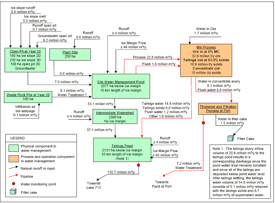
Proponent water budget for the Isua Mine (source: London Mining, 2011).

Oblique aerial photograph looking west from the Greenland ice sheet across the Isua site in 2011. Deeply incised supraglacial meltwater channels are visible draining towards the margin. (source: Lukas Arenson)
References
Andersen et al., 2015. Basin-scale partitioning of Greenland ice sheet mass balance components (2007–2011). Earth and Planetary Science Letters 409: 89-95.
Arenson and Colgan. 2015. Water management challenges associated with mining projects in Greenland. Proceedings of Mine Water Solutions in Extreme Environments. 533-543.
London Mining PLC. 2011. Isua iron ore project: Isua 15 Mtpa scoping study report.
Tags: contact water, Greenland, Isua, meltwater, Mine, runoff
Sixty years ago this month, in September 1954, the US Army Corps of Engineers completed its first summer of construction at Camp TUTO, Greenland. Camp TUTO was tucked against the Greenland ice sheet east of Thule Air Base. The gently sloping ice sheet adjacent to the camp, earmarked for vehicle access to the ice sheet interior, was named Thule Take-Off (or TUTO). Over the summer of 1954, some of the one hundred soldiers stationed at Camp TUTO built a gravel road up the first 1500 meters (4700 feet) of TUTO Ramp. Although that got them above the sometimes bare ice and slush of the lower elevation ice sheet melt zone, it still proved difficult to drive over the soft snow of the higher elevation ice sheet accumulation zone.
In official reports, the US Army Corps of Engineers tested “every off-road military vehicle (probably not excepting Hannibal’s elephants)” in the search for a suitable over-snow vehicle. The M29C Weasel, originally designed as an amphibious vehicle late in the Second World War, had proved disappointing in swampy terrain, but exceptionally nimble on the ice sheet. Although the Weasel was out of production even before construction started at Camp TUTO, it became a beloved backbone of US Army logistics on the Greenland ice sheet for almost two decades.
Constructing TUTO Ramp and adopting the Weasel opened up the interior of the Greenland ice sheet for a wide array of military engineering activities, including the construction of ice sheet runways and under-snow stations, as well as civilian science activities, including recovering the first “deep” ice core and wide-ranging snow and accumulation surveys. An auspicious anniversary of a ground-breaking project in applied glaciology!
(skimmed from my upcoming Cold War science project.)

The view up TUTO Ramp, from the ice margin at Camp TUTO, on to the Greenland ice sheet in 1954. (from Nate Galbreath at thule1954.com)

Modified M29C Weasels in convoy (left) on the Greenland ice sheet in 1954. (from Nate Galbreath at thule1954.com).
Tags: Army Corps of Engineers, Camp TUTO, Greenland, Thule
Posted by William Colgan
on September 24, 2014
Applied Glaciology,
New Research /
Comments Off on Ice Excavation in an Open Ice Pit
I have a paper in this month’s issue of the Journal of Cold Regions Engineering that examines the ice excavation required to establish and maintain an open ice pit. Excavating an open ice pit is a very non-linear applied glaciology problem, as the excavation of ice from an open ice pit enhances subsequent ice flow into the open ice pit. This is because ice velocity is very sensitive to changes in ice geometry, with third and fourth order dependencies on ice slope and thickness respectively! The paper examines scenarios based on excavating an open ice pit on the Greenland ice sheet margin that extends 1000 m into the ice sheet, with a 200 m high ice wall. That is the approximate dimension of the Isua Prospect, Greenland, which is projected to excavate about 36,000,000 tonnes of glacier ice per year.
Working with such unnatural combinations of ice slope and ice thickness compels you to reconsider fundamental principles of glacier mechanics, such as the appropriate relation between stress and strain at tremendous basal shear stresses, which are inconceivable in virtually all natural glacier settings. Despite an increasingly pressing need for a comprehensive understanding of how glaciers respond to highly transient forcings, however, most private sector glacier management projects cannot contribute meaningful observational data to advance such fundamental science due to proprietary considerations. Perhaps that can change in the future!
W. Colgan. 2014. Considering the ice excavation required to establish and maintain an open ice pit. Journal of Cold Regions Engineering. 28: 04014003. doi:10.1061/(ASCE)CR.1943-5495.0000067. Available here.
Supplementary online material (including animations): http://www.williamcolgan.net/som/CRENG113

Cross sectional ice velocities flowing into an open ice pit at excavation years 2.5 (left) and 10.0 (right) sampled from 30-year animations. Dashed black line denotes original ice surface, dash red line denotes ice pit wall. (from Colgan, 2014)
Tags: Isua, Kumtor, open ice pit


