BLOG

Glaciology History

Unprecedented Greenland Glaciology Database

Posted by William Colgan on September 23, 2016
Glaciology History, New Research / Comments Off on Unprecedented Greenland Glaciology Database

The glaciological archive of the Geological Survey of Denmark and Greenland has accumulated both dust and documents over the years. This makes searching through this archive for glacier surface mass balance measurements a tedious task, as it means looking at every individual item. The occasional discovery of hand-written field notes describing a ten-year surface mass balance record can feel like finding a diamond in the rough.

Over the past five years, Horst Machguth led a team of 34 authors from 18 institutions in a near-exhaustive collection of historical surface mass balance observations from the Greenland ice sheet ablation area and peripheral glaciers. The database, which now contains 3000 measurements of surface mass balance, was published online this July in the Journal of Glaciology1. The measurements span 123 years, from the earliest surface mass balance measurements of Erich von Drygalski’s 1882-1883 Greenland Expedition of the Berlin Geographical Society, up to present-day automated weather station measurements.

temporal_overview_incl_map_v5_flat

Figure 1 – Overview of the data contained in the surface mass-balance database. (a) Temporal availability of data for each site and temporal resolution of the data. (b) Number of active measuring sites over time. (c) Number of active measuring points over time.

Approximately 60 % of the measurements were sourced from grey literature and unpublished documents scoured from the archives of the Geological Survey of Denmark and Greenland. Almost forgotten and inaccessible to scientists outside the Survey, they are essentially once again “new to science”. Some measurements, however, remain elusive, like those of Simpson’s 1952-1954 British North Greenland Expedition, and some other mid-20th Century expeditions.

Most measurements were made prior to the widespread adoption of handheld GPS devices. Making these data functional in today’s computer-based research environment turned out to be a major task, as it required translating numerous historical site diagrams into georeferenced latitude and longitude coordinate systems. Innovative solutions were adopted to translate ice surface elevation measurements made by the US Army Corps of Engineers (USACE) into surface mass balance values: cross-sectional profile of a supra-glacial access road could be translated into year-on-year changes in surface elevation equivalent to surface mass balance.

georef_nobles_v2_flat

Figure 2 – A US Army Corps of Engineering map of Nunatarssuaq Ice Ramp georeferenced with a modern digital elevation model.

Having brought together these temporally and spatially diverse measurements into a common digital database now offers an unprecedented opportunity to evaluate the accuracy of surface mass balance simulated by regional climate models. Even on their own, however, the data highlight the diverse rates of change in surface mass balance with elevation around the periphery of the Greenland ice sheet. The value of this data rescue project is perhaps highlighted by the fact that the database has already been used in at least five studies. The database provides a unique tool for understanding the climate sensitivity of Greenland glacier and ice sheet melt over the past century!
1MACHGUTH, H., THOMSEN, H.H., WEIDICK, A., AHLSTRØM, A.P., ABERMANN, J., ANDERSEN, M.L., ANDERSEN, S.B., BJØRK, A.A., BOX, J.E., BRAITHWAITE, R.J., BØGGILD, C.E., CITTERIO, M., CLEMENT, P., COLGAN, W., FAUSTO, R.S., GLEIE, K., GUBLER, S., HASHOLT, B., HYNEK, B., KNUDSEN, N.T., LARSEN, S.H., MERNILD, S.H., OERLEMANS, J., OERTER, H., OLESEN, O.B., SMEETS, C.J.P.P., STEFFEN, K., STOBER, M., SUGIYAMA, S., VAN AS, D., VAN DEN BROEKE, M.R. and VAN DE WAL, R.S.W. (2016) Greenland surface mass-balance observations from the ice-sheet ablation area and local glaciers. Journal of Glaciology, 1–27. doi: 10.1017/jog.2016.75.

Tags: , , , , , ,

Greenland data rescue: An appeal

Posted by William Colgan on November 24, 2014
Communicating Science, Glaciology History, New Research / Comments Off on Greenland data rescue: An appeal

As described in this month’s newsletter No 7, the Programme for Monitoring of the Greenland Ice Sheet (PROMICE) is nearing completion of its comprehensive database of surface mass budget observations from the Greenland ice sheet melt area and peripheral glaciers. We now have just over 2400 unique observations spanning from the 1938 Freja Glacier expedition to the present. Approximately half these observations have never been published. These historic measurements were fragmented across studies, most of which were pre-digital or unpublished, effectively making this highly valuable data inaccessible to the global research community. Despite our best efforts, however, we are still missing data from a handful of known expeditions. For example, does someone you know perhaps have a copy of Alfred Wegener’s 1930 Qaamarujuk Glacier observations? There is a chance we might even be unaware of some expeditions, especially recent private sector prospecting work. Please get in touch with Horst Machguth (homac@byg.dtu.dk) of the www.promice.dk team if you can help us out with this community data assimilation project!

Colgan, W., H. Machguth and A. Ahlstrom. 2014. Data Rescue: Greenland Surface Mass Budget Database. PROMICE newsletter No 7. Ed. S. Andersen and H. Pedersen.

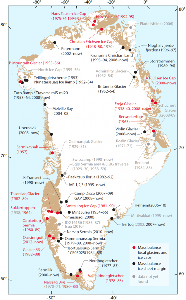
database_map

Map of the location, with temporal description, of the Greenland ice sheet melt area and local glacier surface mass budget observations presently contained in the database. The grey sites are the missing data (from a manuscript in preparation).

Tags: , , , , ,

Sixty Years of Snow Runways

Posted by William Colgan on November 14, 2014
Cold War Science, Glaciology History / 3 Comments

About sixty years ago, in September 1955, the US Army Corps of Engineers conducted the first test landings of wheeled military transport planes on a prepared snow runway at Site II, Greenland. The 3000 meter (10,000 foot) snow runway was prepared by repeatedly pulverizing and compressing the ice sheet’s snow surface with low ground pressure tractors. Driving the tractors from Camp TUTO to Site II, high in the ice sheet interior, took several days.

Eight successful landings with a C-47 Skytrain, led to six successful landings with a C-54 Skymaster, and finally seven successful landings with a C-124 Globemaster. Landing the pug-nosed C-124, which has an empty weight of 45,000 kg (100,000 lbs), on prepared snow runways formed the backbone of ice sheet logistics in both Greenland and Antarctica throughout the International Geophysical Year (1957-1958). The slightly more nimble ski-equipped LC-130 Hercules, now a symbol of polar research, was not tested in Northwest Greenland for six more years.

So, perhaps a nod to the 60th anniversary of snow runways, without which ice sheet camps and their precious ice cores and other glaciological data would not be possible!

Correction: In an earlier post version I said the first C-124 usage of a snow runway was in September 1954. In fact, the snow runway technique was developed in September 1954, but the first C-124 usage of a snow runway was not until September of 1955. The 59.5th anniversary of transport planes and snow runways?

Polar Ice Coring and IGY 1957-58: An Interview with Dr. Anthony J. “Tony” Gow.

(skimmed from my upcoming Cold War science project.)


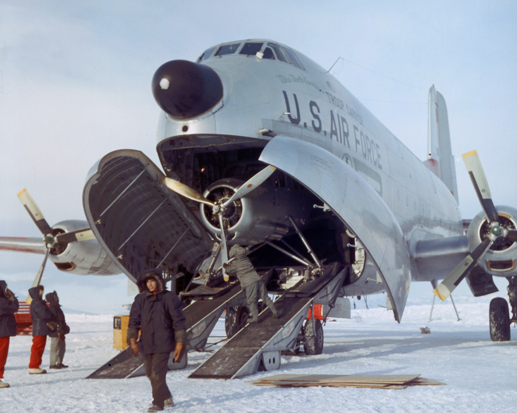
C124_icecap

A wheeled C-124 Globemaster unloading on a snow runway at McMurdo Station, Antarctica, to deliver a smaller ski-equipped plane in 1956 (photo by Jim Waldron; http://icecores.org)

C130_icecap

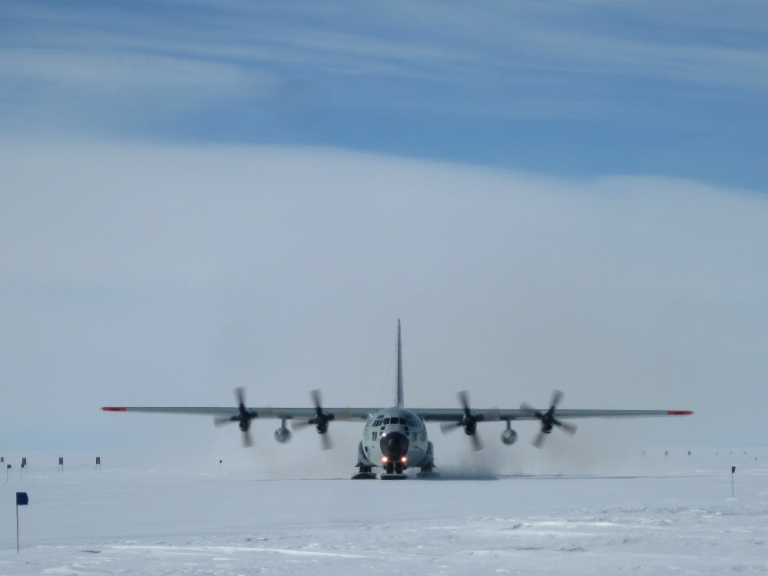
A ski-equipped C130 Hercules taxing at Dye-2, Greenland, after dropping of our field party for there weeks in the spring of 2013. (personal photo!)

Tags: , , , , , ,

Camp TUTO Sixty Year Anniversary

Posted by William Colgan on September 30, 2014
Applied Glaciology, Cold War Science, Glaciology History / 16 Comments

Sixty years ago this month, in September 1954, the US Army Corps of Engineers completed its first summer of construction at Camp TUTO, Greenland. Camp TUTO was tucked against the Greenland ice sheet east of Thule Air Base. The gently sloping ice sheet adjacent to the camp, earmarked for vehicle access to the ice sheet interior, was named Thule Take-Off (or TUTO). Over the summer of 1954, some of the one hundred soldiers stationed at Camp TUTO built a gravel road up the first 1500 meters (4700 feet) of TUTO Ramp. Although that got them above the sometimes bare ice and slush of the lower elevation ice sheet melt zone, it still proved difficult to drive over the soft snow of the higher elevation ice sheet accumulation zone.

In official reports, the US Army Corps of Engineers tested “every off-road military vehicle (probably not excepting Hannibal’s elephants)” in the search for a suitable over-snow vehicle. The M29C Weasel, originally designed as an amphibious vehicle late in the Second World War, had proved disappointing in swampy terrain, but exceptionally nimble on the ice sheet. Although the Weasel was out of production even before construction started at Camp TUTO, it became a beloved backbone of US Army logistics on the Greenland ice sheet for almost two decades.

Constructing TUTO Ramp and adopting the Weasel opened up the interior of the Greenland ice sheet for a wide array of military engineering activities, including the construction of ice sheet runways and under-snow stations, as well as civilian science activities, including recovering the first “deep” ice core and wide-ranging snow and accumulation surveys. An auspicious anniversary of a ground-breaking project in applied glaciology!

(skimmed from my upcoming Cold War science project.)

TUTO_Ramp_in_1954

The view up TUTO Ramp, from the ice margin at Camp TUTO, on to the Greenland ice sheet in 1954. (from Nate Galbreath at thule1954.com)

Weasels_on_the_ice_sheet_in_1954

Modified M29C Weasels in convoy (left) on the Greenland ice sheet in 1954. (from Nate Galbreath at thule1954.com).

Tags: , , ,